-
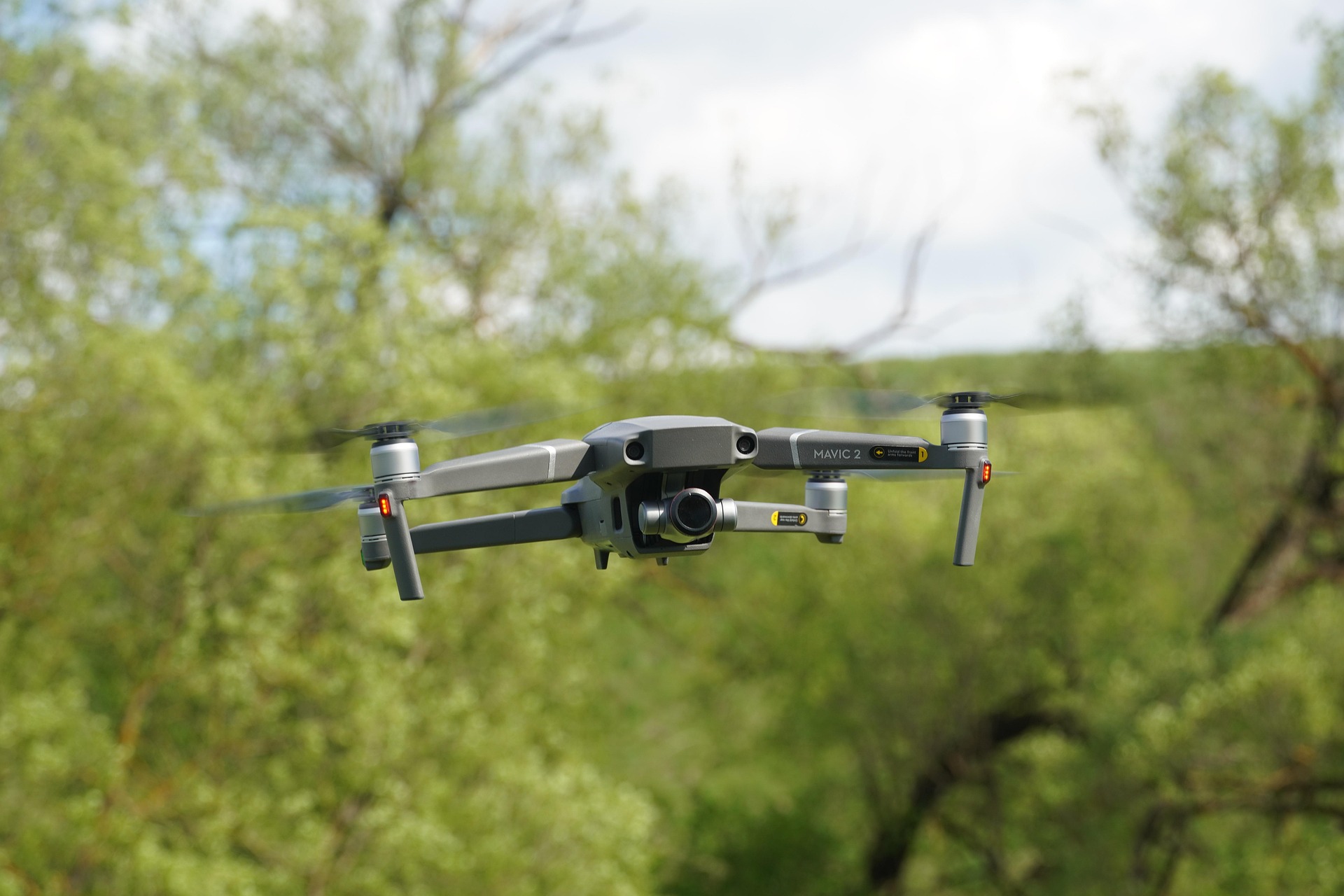
Why Drones with 4K Cameras and Thermal Imaging Are the Best Choice for Surveying and UAV Applications
-
Search and Rescue Drones: Revolutionizing Emergency Response Operations
-
FPV Drone Racing: Achieving 150km/h Speed with Precision Control
-
Unleashing Power: Heavy Lift Drone 100kg Payload Capability Explained
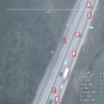
Modern Drone Surveying Solutions Drone surveying utilizes unmanned aerial vehicles equipped with advanced sensors to collect high-resolution data for various industries. This technology creates precise maps and 3D models for construction, agriculture, and other sectors where traditional methods prove costly, time-consuming, and challenging to implement in hazardous areas. Modern surveying solutions like the Carbon Fibre Fuselage Drone with Dynamic AI Tracking combine 4K cameras and thermal imaging technology to provide comprehensive surveying capabilities. These advanced FPV drones deliver detailed visual and thermal data, transforming how industries approach data collection and analysis. Advantages of 4K Cameras in Drone Surveying 4K resolution provides 3840x2160 pixels of crystal-clear imagery, enabling detection of minute details as small as a few centimeters. This high-definition capability allows professionals to identify concrete cracks or detect diseased plant leaves with unprecedented clarity. Enhanced Image Quality with HDR High Dynamic Range (HDR) technology significantly improves image quality in challenging lighting conditions, whether in bright sunlight or shadowy areas. This feature reduces deep shadows and eliminates overexposed highlights, ensuring consistent image quality throughout the survey area. Precision Mapping and 3D Modeling 4K video facilitates the creation of accurate maps and detailed 3D models during daylight operations. High frame rates (such as 60fps) enable smooth video recording while minimizing motion blur during flight operations. The versatility of 4K cameras extends to pairing with multi-spectral sensors for comprehensive plant health analysis. The Carbon Fibre Fuselage Drone features a dual-light camera system with 2K high-definition visible light camera supporting 30x electronic zoom, capturing clear details from significant distances. This makes it particularly suitable for professional surveying applications requiring precise visual data collection. Critical Role of Thermal Imaging in Drone Applications Thermal imaging cameras detect invisible infrared energy emitted by objects, creating color-coded images based on temperature variations. This technology remains effective in complete darkness, through smoke, or in foggy conditions, significantly extending operational hours for drone missions. Identifying Hidden Thermal Issues Thermal imaging reveals heat-related problems invisible to the naked eye. Applications include identifying malfunctioning cells in solar panels, detecting insulation weaknesses in buildings where heat escapes, and locating individuals during search and rescue operations through body heat signatures. Agricultural and Industrial Applications Farmers utilize thermal imaging to monitor crop water stress and check livestock health, while industrial applications include equipment monitoring and maintenance planning. High-resolution thermal sensors capture finer details, enhancing the accuracy of thermal analysis. Professional surveying equipment like the Carbon Fibre Fuselage Drone incorporates high-resolution thermal imaging cameras with 384×288 resolution, making them ideal for thermal inspection applications in various environmental conditions. Synergistic Benefits of 4K and Thermal Imaging Combining 4K and thermal imaging data provides simultaneous visualization of both physical and thermal worlds. Capturing both data types during a single flight mission saves significant time and resources while delivering comprehensive situational awareness. Integrated Data Analysis Specialized software enables the overlay of thermal image layers onto clear 4K photographs, precisely pinpointing problem areas. This integrated approach reduces the likelihood of false alarms and provides more reliable information for decision-making. Practical Applications During power line inspections, 4K cameras identify broken components while thermal imaging detects dangerous overheating connections. In environmental work, this combination helps track wildlife or identify illegal pollution sources with unprecedented accuracy. Real-World Applications and Case Studies Construction sites utilize drone surveying to track progress and measure earthwork, with reported time savings of up to 30% compared to traditional surveying methods. Agricultural applications include field mapping for precision fertilization and irrigation guidance, optimizing crop yields through data-driven decisions. Industrial and Commercial Use Cases Mining companies employ drones for inventory management, achieving precise volume measurements of stockpiles. The technology's versatility extends to various sectors requiring accurate spatial data and thermal analysis. Professional Surveying Solution The Carbon Fibre Fuselage Drone with Dynamic AI Tracking represents the pinnacle of surveying technology, featuring 35-minute flight endurance, 3KG load capacity, and 20KM image transmission range. This advanced surveying drone combines intelligent AI dynamic tracking with dual-frequency communication for reliable performance in complex environments. Explore Professional Surveying Drones
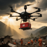
Advanced drone technology is transforming how emergency services locate missing persons, assess disaster situations, and deliver critical supplies with unprecedented speed and efficiency. How Search and Rescue Drones Are Saving Lives Search and rescue drones are fundamentally changing emergency response operations, providing capabilities that traditional methods cannot match. These advanced aerial vehicles are equipped with cutting-edge technology that enables them to locate missing persons in hazardous environments, assess disaster situations, and deliver essential supplies. Drones have become indispensable tools in modern rescue missions, with applications ranging from mountain search operations to natural disaster response. Advanced Drone Platform: D600 The D600 multifunctional flight platform represents the next generation of search and rescue technology. With its compact design, full carbon fiber integration, 680mm wheelbase, and impressive 90-minute flight time (without payload), the D600 provides a customized solution for professional applications across various industries. This advanced platform is particularly well-suited for extended search and rescue operations where endurance and reliability are critical. Key technologies such as thermal imaging, autonomous flight, and real-time data transmission make drones invaluable in life-saving scenarios. The integration of these technologies allows rescue teams to operate more safely and effectively in challenging conditions. Search and Rescue Drone Technology Fundamentals The effectiveness of drones in rescue operations relies on multiple technological components. Multirotor drones provide hovering capability for detailed inspection, while fixed-wing drones offer longer flight times suitable for covering large search areas. Imaging Systems High-resolution optical zoom cameras can identify small details from safe distances, such as clothing colors or movement patterns. Thermal imaging cameras detect body heat to locate people at night, in dense vegetation, or under rubble. Navigation & Communication GPS and GLONASS systems ensure precise navigation and position marking. First-person view (FPV) systems provide operators with real-time situational awareness. Drones can also integrate beacon receivers to detect personal locator beacons. Environmental Resilience Weather-resistant designs enable drone operation in rain, snow, or strong winds, ensuring mission continuity regardless of weather conditions. D600 Technical Capabilities The D600 drone features exceptional technical specifications that make it ideal for search and rescue operations. With a 20KM video transmission distance, 90-minute battery endurance (without payload), and remote data link capabilities, it provides the extended operational range needed for large-area searches. The platform's FPV view and excellent scalability allow for customization based on specific mission requirements. Key Performance Metrics: Flight Time: 90 minutes (no payload) Transmission Range: 20KM Max Speed: 55 km/h Wind Resistance: 10 m/s Hovering Accuracy: Vertical ±0.8m, Horizontal ±2.5m Real-World Applications and Case Studies Drones have been successfully deployed in various emergency situations, demonstrating their practical value in real-world scenarios. Successful Deployments In nighttime mountain rescues, drones using thermal imaging have located missing hikers. During flood disasters, they assess damaged infrastructure and identify people trapped on rooftops. Drone teams employ grid search patterns to systematically cover large areas when searching for missing persons. Supply Delivery and Assessment Drones deliver medical supplies, life jackets, or communication equipment to remote areas or disaster sites. High-resolution cameras document disaster damage for resource allocation and insurance claims, while gas sensors assess air quality following hazardous material leaks. D600 Payload Options for Search and Rescue The D600 platform offers multiple payload options specifically beneficial for search and rescue operations: C10 Gimbal: 2K distortion-free imaging with lightweight design and three-axis stabilization TQ10N Gimbal: 10x optical zoom, three-axis stabilization, 2K photo and video storage C20 Gimbal: 23x optical zoom, three-axis stabilization, adjustable focus spotlight These advanced gimbal systems enable rescue teams to capture clear imagery in various conditions, from broad area surveys to detailed identification of individuals. Speaker systems mounted on drones facilitate communication with survivors or provide instructions, enhancing the coordination of rescue efforts. Innovation and Emerging Technologies Drone technology continues to evolve, pushing the boundaries of rescue capabilities through innovative approaches and advanced systems. Artificial Intelligence and Automation AI algorithms analyze drone footage to automatically detect people or anomalies. Swarm technology enables multiple drones to coordinate efforts, share data, and cover wider areas more efficiently. Advanced Flight Systems Autonomous drones can follow pre-programmed search patterns and return precise coordinates without continuous human guidance. The integration with ground robots or underwater ROVs creates comprehensive search systems. D600 Advanced Control Systems The D600 features sophisticated control systems that enhance search and rescue operations. The advanced ground station application includes smart waypoint planning, autonomous operation, automatic follow, and one-key return functions. With a 20KM control range and 2K video transmission (4K/60fps with frequency hopping technology for stable transmission), operators maintain clear situational awareness throughout missions. The intelligent control system features a 7-inch, 1920×1200 IPS high-brightness screen running Android, providing an intuitive interface for complex operations. The smart battery system with high-energy lithium-ion batteries, intelligent discharge, and control systems ensures reliable power management during extended missions. Hybrid drones combine multirotor and fixed-wing advantages with vertical take-off and landing (VTOL) capability. Tethered drone systems provide continuous power through physical cables, enabling hours of uninterrupted operation. Collision avoidance systems using sensors and AI enable safe navigation in complex environments. Operational Protocols and Best Practices Safe and effective rescue missions require adherence to established procedures and protocols that ensure operational success while maintaining safety standards. Pre-Mission Preparation Pre-mission checklists include battery levels, sensor functionality, and weather assessments. Airspace coordination protocols ensure drones don't conflict with rescue helicopters or other aircraft. Communication and Data Management Data management procedures securely store and analyze collected footage as evidence. Team communication protocols maintain clear information flow between drone operators, incident commanders, and rescue personnel. D600 in Professional Applications The D600 drone is designed for professional applications across multiple sectors: Security Applications: Automatic patrols and fixed-point monitoring of specific route areas with real-time monitoring and local recording Broadcast Systems: Equipped with high-decibel public address systems for broadcasting to urban and surrounding areas Industry Applications: Suitable for power, fire, police, and other industries with customizable specific functions This versatility makes the D600 an ideal platform for various emergency response scenarios, from natural disasters to security incidents. Emergency procedures handle drone system failures or weather changes, while privacy considerations balance search efficiency with individual rights. Maintenance plans ensure drone reliability under demanding conditions. Enhance Your Search and Rescue Capabilities Discover how the advanced D600 drone platform can transform your emergency response operations with its exceptional endurance, transmission range, and customizable features. Explore D600 Specifications Or browse our complete range of FPV drones for professional applications Future Directions and Challenges The future development of drone technology includes battery improvements for extended flight times, while regulatory advancements may enable beyond visual line of sight (BVLOS) operations. Advances in artificial intelligence and machine learning will accelerate threat detection and decision-making processes. Public acceptance challenges can be addressed through education and demonstration, while cost barriers are mitigated through more affordable professional-grade drone solutions. Standardization efforts ensure interoperability between different agencies and jurisdictions, while climate change and extreme weather events increase the demand for drone response capabilities. The continuous evolution of platforms like the D600 ensures that search and rescue teams will have access to increasingly sophisticated tools for saving lives.
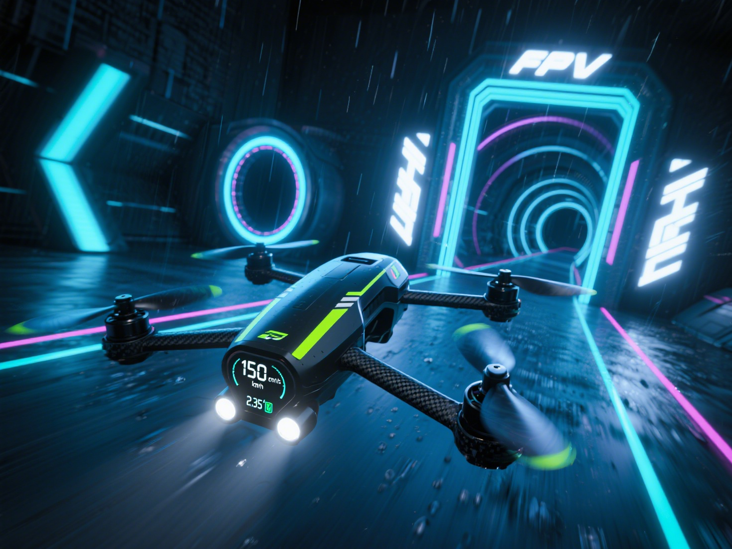
First-person-view (FPV) drone racing represents the ultimate fusion of technology and adrenaline. For enthusiasts wondering what does FPV drone mean, it's experiencing flight through the drone's perspective using real-time video transmission. Serious racers understand that hitting 150km/h isn't just a benchmark — it's the competitive edge that separates champions from participants. This comprehensive guide explores how to select the perfect FPV drone capable of dominating race circuits while maintaining optimal control. Understanding FPV Camera Drone Performance Metrics When selecting a high-speed FPV camera drone, these performance indicators determine racing success: Frame Architecture: Lightweight carbon fiber designs enhance agility for these drone quadrotor systems Motor and ESC Integration: High KV brushless motors paired with rapid-response ESCs enable explosive acceleration Propeller Efficiency: Advanced 3-blade designs with high-RPM materials ensure maximum thrust Flight Control Systems: Platforms like Betaflight or KISS enhance stability for fast drone with camera applications Video Transmission Quality: Low-latency HD systems (DJI O3) provide real-time control during high-speed maneuvers Engineering the Perfect Custom Drone for Speed Achieving consistent 150km/h performance requires meticulous component selection and aerodynamic optimization: High-Torque Motor Systems: 2810 or 2407 series motors deliver the acceleration needed for racing Advanced Power Systems: 6S LiPo batteries (22.2V) provide sustained power delivery Aerodynamic Optimization: Streamlined builds reduce drag for maximum efficiency Balanced Propulsion: Larger propellers (7*4*3 configuration) ensure stable thrust distribution These elements combine to create custom drone configurations that excel in both speed and stability. Spotlight: 7-Inch Racing FPV Drone - The Speed Specialist The 7-inch traversing FPV drone represents the pinnacle of racing engineering, specifically designed for long-distance high-speed competition. Technical Specifications: Control System: F405 flight controller Power Management: 4-in-1 50A ESC Video Transmission: 2.5W VTX system Imaging: Miniature FPV camera with real-time transmission Propulsion: Durable 2810 series motors Aerodynamics: 7*4*3 propeller configuration Power Source: 22.2V 4500mAh battery Performance: 150km/h maximum speed Operational Range: 15-20km distance capability Endurance: 21-30 minute flight duration Capacity: 2-3.5kg payload support Compact Power: FPV Small Drone Considerations While larger drones dominate speed competitions, FPV small drone options offer unique advantages for technical courses and training scenarios. These compact systems provide exceptional maneuverability in confined spaces while maintaining impressive acceleration profiles. Advanced Racing Techniques for FPV Drone Pilots Course Mastery: Pre-plan optimal racing lines to minimize unnecessary maneuvers Throttle Management: Maximum acceleration on straightaways, controlled speed in corners Precision Cornering: Master inside-line techniques for reduced lap times Dynamic Handling: Practice rapid direction changes and emergency maneuvers Simulator Training: Utilize platforms like Liftoff or Velocidrone for skill development Maintenance Protocols for Competition-Ready Drones Post-Flight Analysis: Comprehensive inspection of propellers, motors, and frame integrity Optical Maintenance: Regular cleaning of camera lenses and cooling systems System Calibration: Frequent flight controller recalibration for precision control Component Replacement: Proactive replacement of worn batteries and propellers Storage Best Practices: Proper environmental controls to prevent moisture damage Safety Framework for High-Speed FPV Operations Regulatory Compliance: Strict adherence to local drone operation regulations Operational Zones: Exclusive use of approved flying areas away from restrictions Protective Equipment: Mandatory FPV goggles and safety gear during events Fail-Safe Systems: Activated return-to-home and auto-land protocols
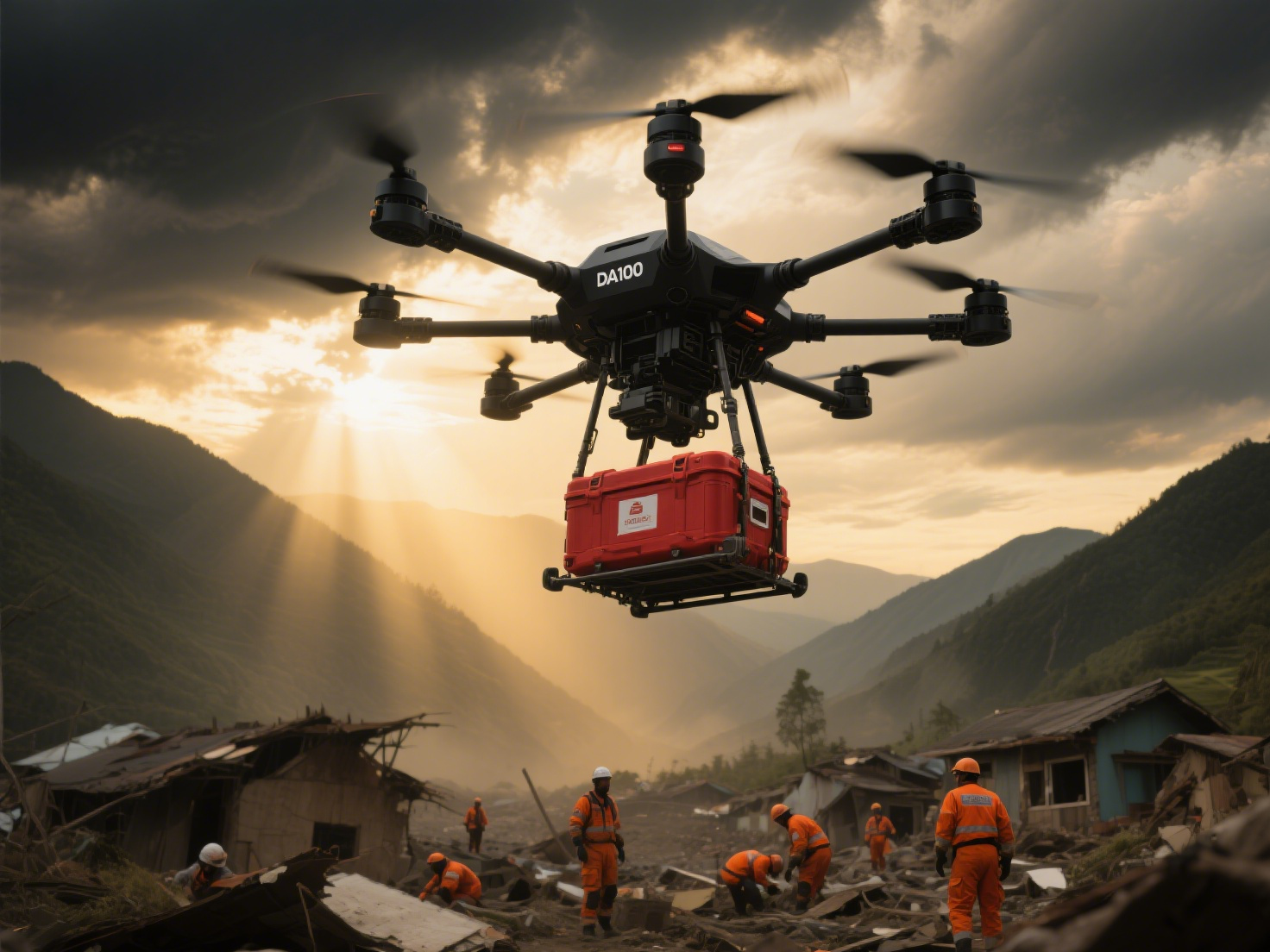
Revolutionizing Transport: The DA100 140kg Payload Heavy Lift Drone The Era of Heavy Lift Drones Has Arrived The logistics and emergency response sectors are undergoing a massive transformation, driven by the capabilities of heavy lift drones. These advanced unmanned aerial vehicles (UAVs), with their exceptional payload capacities, are redefining how we transport substantial cargo. Leading this change is the DA100, a large-load logistics heavy lift drone designed to carry up to 140kg, offering unprecedented efficiency and capability. Unlike standard drones, heavy lift drones like the DA100 provide significant advantages, including vastly greater payload capacity and extended flight range. This makes them ideal for transporting goods weighing 100kg, 200kg, and beyond, meeting rigorous industrial demands. With optimized propulsion and intelligent control systems, the DA100 ensures safe and efficient transportation of payloads exceeding 100kg. DA100: A Premier Heavy Lift Drone for Demanding Missions The DA100 is an industrial-grade heavy lift drone engineered for critical operations, including firefighting, aerial logistics, and heavy lifting tasks. Its airframe is constructed from high-strength composite carbon fiber, and with an IP68 waterproof rating, this robust drone can reliably support its maximum payload of 140kg even in adverse weather conditions like rain. 140kg Max Payload Capacity 45 min Max Flight Time 240kg Max Takeoff Weight 30km Remote Control Distance Engineering a Reliable Heavy Lift Drone To safely transport payloads of 100kg and more, the DA100 heavy lift drone incorporates a robust carbon fiber structure that delivers an ideal balance of lightweight design and exceptional strength. It is powered by multiple high-output motors and large-diameter propellers to guarantee stable performance during takeoff and landing, even at maximum capacity. The drone's military-grade triple-redundant flight control system ensures unwavering stability and safety in complex operational environments. Coupled with its IP68 rating, the DA100 is built to perform reliably in harsh conditions, making it an indispensable tool for emergency response teams. Key Technical Specifications of the DA100 Heavy Lift Drone Parameter Specification Body Material High-strength Composite Carbon Fiber Maximum Payload 140kg Maximum Takeoff Weight 240kg Flight Time (100kg load) 20-45 minutes Battery Capacity 120,000mAh Flight Control System Military-grade Triple-Redundant System Maximum Wind Resistance ≥6 levels (instantaneous ≥8 levels) Remote Control Distance 30km (open environment) Waterproof Rating IP68 (capable of flying in light rain) Transformative Applications for Heavy Lift Drones Heavy lift drones like the DA100 are revolutionizing numerous industries. Here are some of their key applications: 🚑 Emergency Medical Transport Enable rapid delivery of critical medical supplies, blood, and vaccines to remote or disaster-stricken areas where traditional transport methods fail. 🔥 Firefighting & Disaster Response Deliver firefighting equipment or water directly to inaccessible locations, proving critical for wildfire and natural disaster response. 📦 Logistics & Remote Delivery Transport materials and equipment to remote sites, drastically cutting delivery times and reducing reliance on manpower and infrastructure. 🏗️ Infrastructure Inspection Conduct detailed inspections of bridges, power lines, and other critical infrastructure from a safe distance using high-resolution cameras. ⚡ Military & Defense Logistics Execute rapid resupply missions in challenging environments without the need for runways, thereby minimizing risks to personnel. 🏝️ Island & Mountain Logistics Overcome geographical barriers to deliver essential supplies to isolated communities, eliminating the need for expensive infrastructure projects. Uncompromising Safety in Heavy Lift Drone Design Transporting payloads equivalent to a heavy lift drone 200kg class requires rigorous safety engineering. The DA100 incorporates multiple redundant systems, including dual power systems, precision GPS, obstacle avoidance radar, and automated return-to-base functions. All flight parameters are meticulously optimized for payload security. The drone features 360-degree situational awareness and emergency landing protocols, which are essential for safe operations in urban environments where avoiding obstacles and populations is paramount. The Future of Heavy Lift Drone Technology The DA100 stands as a pinnacle of current heavy lift drone technology, but innovation continues. The future will see AI-powered flight optimization, advanced battery tech for longer range, and new materials for even greater efficiency. As regulations adapt to accommodate large cargo drones, and with the support of 5G/6G networks, heavy lift drones will become integral components of smart logistics networks, working alongside automated systems to create seamless, highly efficient supply chains worldwide.
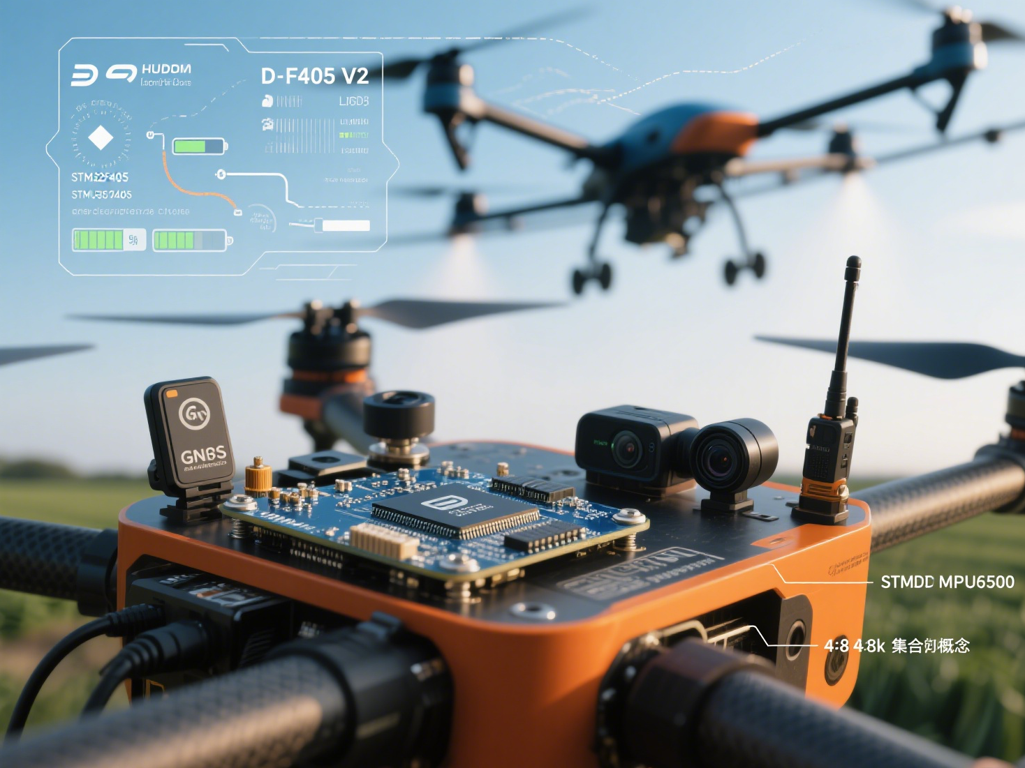
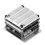
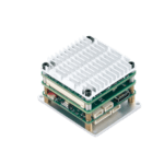
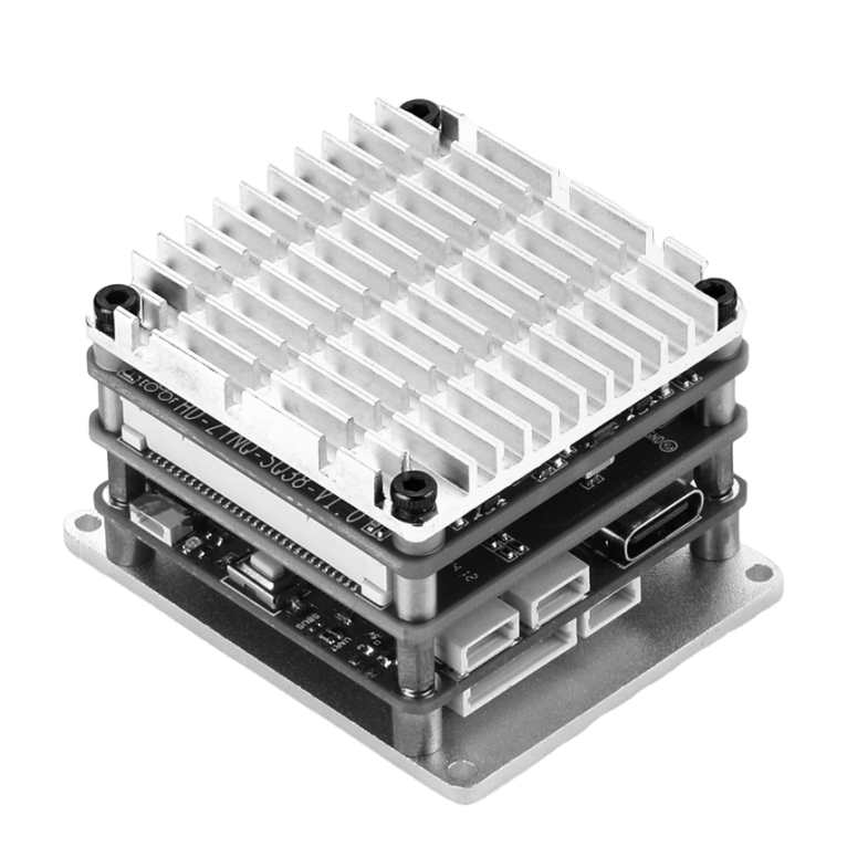
Introduction As unmanned aerial vehicles (UAVs) transform operations across logistics, agriculture, defense, and public safety, the demand for robust, intelligent flight controller systems has reached unprecedented levels. Modern flight controllers have evolved from basic stabilization units into the central nervous system of enterprise drones. This article examines critical integration strategies for navigation, obstacle avoidance, communications, and payload systems - with a special focus on implementing high-performance controllers like the D-F405 V2 in commercial applications. What Is a Flight Controller System? The flight controller (FC) serves as the computational core of UAVs, responsible for: Real-time flight stabilization through sensor feedback Processing commands from ground control or autonomous systems Managing communication between sensors, motors, and peripherals Enterprise-grade controllers feature industrial components like STM32 processors, RTOS capabilities, and support for firmware platforms including PX4 and ArduPilot. The D-F405 V2 exemplifies this category with its STM32F405RGT6 chip and professional sensor suite. Why Integration Matters for Enterprise UAVs Seamless subsystem integration delivers critical advantages: Reduced latency and hardware conflicts Enhanced mission efficiency through sensor fusion Autonomy in GNSS-denied environments Simplified architecture and lower development costs Key Integration Modules & Implementation Strategies 1. Navigation Systems Integration Enterprise UAVs require redundant, high-precision navigation. Flight controllers like the D-F405 V2 support: Multi-constellation GNSS/RTK positioning MPU6500 gyroscope for precise attitude control BMP280/DPS310 barometer for altitude hold Sensor fusion algorithms for real-time data synthesis Implementation Tip: Utilize the controller's 5 universal serial ports to connect GPS modules while maintaining separate IMU communication channels. 2. Obstacle Avoidance Systems The D-F405 V2's multiple UART interfaces enable simultaneous connections to: LiDAR for 3D mapping Stereo vision systems for object recognition Ultrasonic sensors for precision landing Radar modules for all-weather detection Design Consideration: Leverage the 16MB black box to log avoidance maneuvers for algorithm refinement. 3. Communication Systems With 5 configurable serial ports, the D-F405 V2 supports: MAVLink protocol for ground station communication LTE/5G modules for beyond-line-of-sight operations Redundant radio systems with fail-safe logic Encrypted data transmission Integration Advantage: Dedicated 9V/2A power supply ensures stable operation of communication peripherals. 4. Payload & Mission Systems The controller's 8 motor outputs and power management enable: Precision control of spraying systems in agriculture Synchronized camera gimbal operation for inspection Payload release mechanisms for delivery drones Multi-sensor integration for industrial inspections Industry Applications: Integration in Action Industry Integration Requirements D-F405 V2 Implementation Precision Agriculture Terrain following, spraying control, sensor fusion Barometer for altitude hold, 8CH outputs for nozzle control, serial ports for multispectral sensors Infrastructure Inspection Stable positioning, camera control, obstacle avoidance MPU6500 gyro for stabilization, black box for compliance logging, multiple UARTs for vision systems Logistics Precision landing, payload delivery, indoor navigation 9V power output for release mechanisms, compact 36x36mm footprint, Betaflight/INAV firmware flexibility Technical Specifications: D-F405 V2 Flight Controller Controller STM32F405RGT6 Gyroscope MPU6500 Barometer BMP280 or DPS310 (Optional) Black Box 16MB Motor Outputs 8 Channels Serial Ports 5 Universal Channels Power Output 5V/2.5A & 9V/2A Weight 8.2g Dimensions 36mm x 36mm Mounting 30.5mm x 30.5mm Firmware Betaflight: F405V2MPU6500 / INAV: RCF4V2 Selecting Enterprise Flight Controllers: Key Evaluation Criteria When evaluating controllers like the D-F405 V2 for commercial applications: Processing Power: STM32F405 provides 168MHz ARM Cortex-M4 performance I/O Capacity: 8 motor outputs + 5 serial ports enable complex integrations Sensor Support: Industrial-grade MPU6500 IMU with optional barometric sensors Data Management: 16MB black box for critical mission logging Power Distribution: Dual regulated outputs (5V/9V) for peripherals Firmware Flexibility: Betaflight and INAV compatibility Implementation Best Practices Hardware Integration Utilize the 30.5x30.5mm mounting pattern for vibration-isolated installation Leverage 9V/2A output for high-demand peripherals like LiDAR Implement CAN bus expansion through available serial ports Software Configuration Configure Betaflight/INAV for enterprise-specific flight modes Implement custom failsafe protocols using black box data Develop sensor fusion algorithms using raw IMU/barometer data Reliability Engineering Implement watchdog timers for critical processes Design redundant communication pathways Conduct thermal testing in operational environments Conclusion The D-F405 V2 Flight Controller demonstrates how racing-grade technology can be adapted for commercial UAV applications through strategic integration. Its combination of STM32 processing power, extensive I/O capabilities, and industrial sensors provides a robust foundation for enterprise drone systems. By implementing proper subsystem integration strategies across navigation, obstacle avoidance, communications, and payload management, organizations can develop high-performance UAV solutions optimized for their specific operational requirements. Ready to Integrate Advanced Flight Control? Our engineering team specializes in optimizing flight controllers like the D-F405 V2 for enterprise applications: Custom firmware development (PX4/ArduPilot/Betaflight) Sensor integration and calibration services Environmental testing and validation System architecture design Contact our UAV integration specialists for a free technical consultation
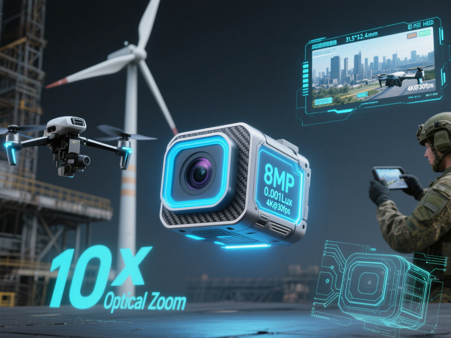
Understanding the Best UAV Camera Market Landscape The search for the best uav camera requires understanding the current market hierarchy, which spans from consumer-grade to industrial-grade and military-grade solutions. Each category offers distinct differences in performance, reliability, and pricing. Among industrial-grade uav camera options, the D-C8110UV 8MP 10X Optical Zoom 4K IP Drone Camera Module stands out as a premium solution that bridges the gap between industrial and military specifications. What Makes the Best UAV Camera? D-C8110UV Technological Excellence Superior Imaging: Core of the Best UAV Camera This advanced uav camera module incorporates a 1/2.8-inch progressive scan CMOS sensor capable of 8MP(3840×2160)@30fps ultra-HD video output. Its exceptional 0.001Lux/F1.6 low-light performance, combined with a 10x optical zoom (4.8mm-48mm) lens, ensures clear imaging in near-total darkness. These features position it among the best uav camera options for professional applications. Intelligent Processing: Next-Generation UAV Camera Technology The integrated 1T computing power intelligent computing unit represents a breakthrough in uav camera technology, supporting deep learning algorithms that enable: Real-time motion detection and tracking capabilities Automatic scene recognition and optimization Intelligent exposure and white balance adjustment Advanced 3D digital noise reduction (3D DNR) Proving Performance: Best UAV Camera in Real-World Applications Power Infrastructure Inspection Case Study In demanding field applications, this best uav camera solution demonstrated exceptional capabilities during a 500kV high-voltage transmission line inspection: Identification of 2mm diameter wire wear from 30 meters distance Early detection of poor contact nodes through thermal imaging overlay Complete inspection coverage of 5km lines in a single flight Military-Grade Performance: Why This Stands as Best UAV Camera Rugged Environmental Performance: Stable operation across extreme temperatures from -30°C to 60°C IP67 protection rating certification for harsh conditions Superior electromagnetic interference resistance exceeding EN61000-6-2 standard Tactical-Grade Capabilities: 10x optical zoom enables human outline identification at 1km distance Ultra-fast electronic shutter speed of 1/100,000 second for high-speed target capture Secure AES256 encrypted video stream transmission Technical Comparison: Best UAV Camera Specifications Parameter D-C8110UV - Best UAV Camera Industrial Average UAV Camera Military Entry-Level Resolution 8MP@30fps 4MP@30fps 12MP@60fps Zoom Capability 10x optical 5x optical 20x optical Low-light Performance 0.001Lux 0.01Lux 0.0001Lux Operating Temperature -30~60°C -20~50°C -40~70°C Weight 101g 150-300g 500g+ Price Range $3,500-$5,000 $1,000-$3,000 $15,000+ Industry Recognition: Expert Verdict on Best UAV Camera "The D-C8110UV redefines expectations for industrial uav camera systems and genuinely deserves consideration among the best uav camera solutions available. Its impressive balance of weight and performance challenges traditional categorization. While it doesn't match the extreme environmental specifications of dedicated military equipment, it exceeds requirements for the majority of professional and quasi-military applications." — Chief Analyst, Unmanned Systems Technology Conclusion: Your Best UAV Camera Choice The D-C8110UV represents the pinnacle of industrial-grade uav camera technology and stands as a strong contender for the title of best uav camera in its class. Through strategic military-grade technology transfer and comprehensive intelligent upgrades, it delivers exceptional value to professional users. As drone applications continue to expand across industries, this high-performance, lightweight camera module establishes new standards for what professionals should expect from the best uav camera solutions driving digital transformation.
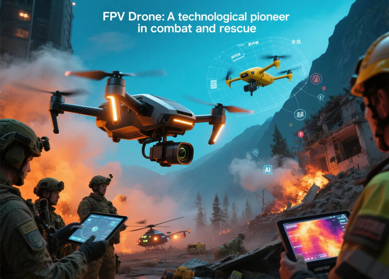
FPV Drones Revolutionize Military Applications and Search and Rescue Operations with Real-Time Intelligence FPV Drone Technology: Enhancing Situational Awareness Through Advanced Systems FPV drone technology fundamentally transforms operator perception through sophisticated camera and video transmission systems. While traditional systems faced latency challenges, modern innovations have dramatically improved response times. This technological advancement provides critical support for both military applications and search and rescue missions, enabling superior situational awareness. Modern FPV drones convert visual data into high-quality video signals through advanced imaging systems, transmitting information wirelessly to ground stations. Operators utilize specialized displays for real-time monitoring, where autonomous navigation capabilities complement manual control. The integration of lightweight batteries ensures extended operational duration while maintaining performance standards. Leading systems like DJI's O3 Air Unit achieve remarkable latency reductions below 30ms through digital transmission protocols. High-resolution optical systems combined with high-refresh-rate displays deliver exceptional image clarity, significantly enhancing operational precision and decision-making speed in critical scenarios. Military Applications: Advanced Reconnaissance and Real-Time Intelligence Gathering FPV drones demonstrate exceptional value in military applications, revolutionizing reconnaissance capabilities and intelligence collection efficiency. These systems provide indispensable support for border security operations, target identification, and tactical missions, delivering crucial real-time intelligence to command centers. These advanced FPV drones conduct covert low-altitude reconnaissance in hostile territories while minimizing soldier exposure. Compared to conventional equipment, they offer superior cost-effectiveness and rapid deployment capabilities. In border protection scenarios, they enable continuous wide-area monitoring, effectively detecting and reporting suspicious activities through AI recognition systems. For tactical operations, frontline units employ FPV drones for rapid terrain assessment, enemy position mapping, and safe route identification. Since 2023, enhanced FPV drones have demonstrated remarkable effectiveness in precision engagement missions and intelligence collection, proving their substantial tactical value in modern warfare. Search and Rescue Applications: Enhanced Efficiency Through Real-Time Monitoring In search and rescue operations, FPV drones dramatically improve missing person localization and disaster site assessment capabilities. Through advanced real-time intelligence transmission, these systems significantly enhance disaster response effectiveness, forest fire monitoring, and emergency rescue operations. FPV drones efficiently survey hazardous environments including mountainous terrain, dense forests, and earthquake-damaged structures. The immediate visual perspective enables rapid target identification and assessment. During forest fire incidents, specialized FPV drones penetrate high-temperature zones to map fire progression patterns, supporting strategic resource deployment decisions. In earthquake response scenarios, compact FPV drones access confined spaces to locate trapped individuals. The 2022 Japanese avalanche rescue operation demonstrated how FPV drones with autonomous navigation capabilities successfully located missing climbers, substantially improving rescue efficiency and success rates. Environmental Adaptability: Robust Performance in Challenging Conditions Contemporary FPV drones maintain operational effectiveness across diverse harsh environments through high-performance propulsion systems and advanced flight control mechanisms. Integrated GPS-assisted autonomous navigation and visual positioning technologies ensure stability in complex terrain during adverse weather conditions including strong winds, precipitation, and dust storms. Manufacturers are developing specialized lightweight batteries and cold-resistant electronic systems for high-altitude and extreme-temperature operations. Selected models demonstrate reliable performance at -20°C with operational endurance exceeding 20 minutes, making them ideally suited for mountain search and rescue missions and extreme environment military applications. Data Security and Privacy: Ensuring Protected Operations Through Advanced Encryption FPV drone operations necessitate rigorous attention to data security and privacy considerations. Real-time video transmission presents potential vulnerability points where sensitive information could be compromised through interception, potentially jeopardizing military applications and rescue missions. Military-grade FPV drones typically incorporate advanced encrypted communication protocols and dedicated frequency bands to prevent unauthorized access. Civilian search and rescue operations must adhere to strict privacy regulations, implementing measures to avoid recording unrelated individuals or private property areas. Technology developers are implementing sophisticated AI recognition protection mechanisms and multi-factor authentication systems to counter electronic interference and cyber intrusion attempts, significantly enhancing operational security across all deployment scenarios. Future Development: Intelligent Systems and Enhanced Autonomous Capabilities FPV drones are evolving toward increasingly intelligent systems. Advanced AI recognition enables automated target identification, facial recognition, and thermal signature detection, substantially improving search efficiency and accuracy. Autonomous navigation technology permits predefined route execution without continuous manual intervention. Multi-sensor integration incorporating infrared imaging, night vision capabilities, radar systems, and GPS technology enables comprehensive operation across all lighting and weather conditions. Future FPV drones will feature advanced lightweight batteries, increased operational speeds, and enhanced computational intelligence - establishing them as indispensable assets in both military applications and search and rescue operations.
Military FPV Drone Technology: AI Vision Systems for Enhanced Situational Awareness and Real-Time Threat Detection Understanding AI FPV Technology in Modern Military UAV Operations AI FPV (Artificial Intelligence First-Person View) represents a revolutionary advancement in unmanned aerial vehicle (UAV) technology. This sophisticated system combines thermal imaging drone capabilities with AI image analysis to provide military personnel with unprecedented situational awareness. Through advanced cameras and AI-powered sensors, the military FPV drone can analyze complex environments in real-time, identify potential threats, and enable immediate operational responses. This technology fundamentally transforms how military patrol units perceive and interact with their operational environments. How AI Vision Systems Power Military FPV Drones The core functionality of AI FPV technology relies on integrated AI vision systems that process environmental data through multiple sensor inputs. Military FPV drones equipped with thermal imaging capabilities capture real-time visual and thermal data, which is then processed by sophisticated AI algorithms for immediate threat assessment. The system's real-time threat detection capabilities are enhanced through encrypted communication channels that ensure secure data transmission between the unmanned aerial vehicle (UAV) and command centers. Operators access this critical information through head-mounted displays or tactical tablets, creating an immersive first-person experience that significantly enhances situational awareness. The AI image analysis component continuously processes visual data, identifying patterns and anomalies that might escape human observation, thereby providing comprehensive battlefield intelligence. Military Applications: From Patrols to Advanced Surveillance Modern military operations leverage AI FPV technology across multiple domains: - Remote battlefield monitoring using thermal imaging drones reduces direct personnel exposure to combat zones - Automated threat identification through AI vision systems detects suspicious vehicles, individuals, or activities - 24/7 operational capability enabled by thermal imaging and night vision technologies - Expanded patrol coverage through integration with various unmanned aerial vehicle (UAV) platforms - Enhanced situational awareness during complex military operations and perimeter security For instance, military FPV drones equipped with advanced AI image analysis can surveil high-risk areas, stream encrypted real-time data to command centers, and automatically flag potential threats for immediate command decision-making. Technical Advantages of AI-Powered Military UAV Systems The integration of AI vision systems with military FPV drones delivers significant operational benefits: - Immediate real-time threat detection and response capabilities within operational seconds - High-precision target recognition through advanced AI image analysis algorithms - All-weather operational capacity, including darkness and adverse environmental conditions - Reduced personnel risk by minimizing direct exposure to hazardous situations - Enhanced mission success rates through automated processing and reduced human error - Secure data transmission via encrypted communication protocols - Comprehensive situational awareness through multi-sensor data fusion Challenges and Future Development in Military UAV Technology Current operational challenges include: - Critical data security requirements for sensitive military intelligence - Dependence on robust encrypted communication networks for reliable operations - Continuous algorithm training needs to minimize AI vision system biases - Significant hardware investment and deployment costs for thermal imaging drone systems Future technological developments focus on: - Enhanced resolution thermal imaging for improved target identification accuracy - Advanced edge computing capabilities for faster AI image analysis - Miniaturized systems for multi-platform military FPV drone deployment - Integration with 5G and satellite networks for global encrypted communication - Improved real-time threat detection algorithms for urban warfare scenarios Ethical Considerations in Autonomous Military Systems Critical ethical questions surrounding AI FPV technology deployment: - Appropriate levels of automation in target identification and engagement decisions - Balancing enhanced security capabilities with civilian privacy protection requirements - Clear accountability frameworks for AI vision system errors or malfunctions - Regulatory guidelines for military FPV drone operations in civilian areas - Transparency requirements for autonomous real-time threat detection systems These considerations demand comprehensive policy frameworks before widespread implementation of advanced unmanned aerial vehicle (UAV) systems with autonomous capabilities. Conclusion: The Future of Military Surveillance Technology AI FPV technology has established itself as a cornerstone of modern military surveillance and patrol operations. The integration of thermal imaging drones with advanced AI vision systems creates unprecedented capabilities for real-time threat detection and enhanced situational awareness. As unmanned aerial vehicle (UAV) technology continues to evolve, the applications of military FPV systems will expand across defense, security, and emergency response domains, fundamentally transforming how military organizations approach surveillance and threat assessment missions. Related Product 7 Inch Traversing Drone with Advanced AI Vision Capabilities

In the rapidly advancing field of drone surveillance technology, the DS30A Three-Light Lightweight Pod stands out as a game-changing solution for professional operators. This cutting-edge AI pod combines three powerful sensor systems into one compact, lightweight package, delivering unprecedented surveillance capabilities for both day and night operations. Unparalleled Multi-Sensor Integration The DS30A represents the pinnacle of drone surveillance technology, integrating three critical sensor systems into a single lightweight pod weighing under 970g. This innovative design provides operators with comprehensive situational awareness in any environment or lighting condition. Key features that set the DS30A apart: Triple-Sensor Fusion: Seamlessly combines visible light, infrared thermal imaging, and AI-based recognition 30x Optical Zoom: Captures clear, detailed images even at extreme distances High-Sensitivity Thermal: Detects heat signatures with exceptional clarity in complete darkness Three-Axis Stabilization: Maintains rock-steady imaging during dynamic flight maneuvers Quick-Release Mount: Enables rapid deployment and equipment changes in the field Technical Specifications System Type Gyro Stabilized Multi-Sensor Pod Total Weight ≤970g Visible Light Resolution 1920x1080 @ 60 fps Visible Light FOV 63° x 35° Thermal Imaging FOV 12.5° x 10° Power Requirements 12-28V DC Tracking Speed ±48 pixels/frame @ 60 fps Operating Temperature -10°C to +50°C Storage Temperature -40°C to +60°C Zoom Capability 30x Optical Stabilization 3-Axis Gimbal AI Features Person/Vehicle Recognition, Intelligent Tracking Advanced AI-Powered Surveillance Technology The DS30A Three-Light Lightweight Pod incorporates sophisticated artificial intelligence algorithms that revolutionize how surveillance data is captured and processed. The system's intelligent multi-sensor linkage automatically selects the optimal imaging mode based on environmental conditions, ensuring operators always have the best possible view. Key technological advantages: Adaptive Sensor Switching: Automatically transitions between visible light and thermal imaging based on lighting conditions Smart Target Recognition: AI algorithms identify and classify people and vehicles in real-time Predictive Tracking: Anticipates target movement patterns for smoother tracking Multi-Target Processing: Capable of tracking multiple objects simultaneously Environmental Adaptation: Compensates for fog, smoke, and other visibility challenges Professional Applications The versatility of the DS30A makes it invaluable across numerous professional sectors where advanced surveillance capabilities are required. Its lightweight design and comprehensive feature set open up new possibilities for drone-based observation and monitoring. Primary application areas: Law Enforcement & Security: Perimeter monitoring, suspect tracking, evidence collection, and crowd surveillance Search & Rescue: Locating missing persons in wilderness areas or disaster zones day or night Industrial Inspection: Detecting heat leaks in pipelines, electrical faults, and equipment malfunctions Border Patrol: Monitoring vast border areas for unauthorized crossings Wildlife Conservation: Tracking animal movements without disturbing natural behavior Firefighting: Identifying hot spots and assessing fire spread through smoke Superior Performance in Challenging Conditions The DS30A is engineered to deliver reliable performance when it matters most. Its rugged construction and advanced stabilization system ensure crisp, stable imagery even in demanding operational environments. Performance highlights: All-Weather Operation: Functions flawlessly in rain, fog, smoke, and complete darkness High-Speed Tracking: Maintains lock on fast-moving targets up to 120km/h Long-Range Identification: Recognizes human figures at distances exceeding 1km Low-Light Excellence: Thermal imaging detects temperature differences as small as 0.05°C Vibration Resistance: Compensates for drone vibrations and wind gusts up to 12m/s Seamless System Integration The DS30A is designed for easy integration with a wide range of professional drone platforms. Its standardized mounting system and flexible power requirements make it compatible with most commercial UAVs used for surveillance applications. Integration features: Universal Mounting: Compatible with standard gimbal mounting systems Plug-and-Play Operation: Minimal setup required for immediate use Multiple Output Options: Supports HD video transmission via various protocols Remote Control: All functions controllable from ground station software Data Logging: Records mission data for post-flight analysis Why Choose the DS30A Three-Light Lightweight Pod? The DS30A Three-Light Lightweight Pod represents the future of drone surveillance technology. By combining three powerful sensor systems with advanced AI processing in a compact, lightweight package, it delivers capabilities previously requiring multiple separate systems. For professional operators who demand the highest level of surveillance capability without compromising on payload capacity or flight time, the DS30A offers an unbeatable combination of features: Comprehensive 24/7 surveillance capability in a single integrated system Significant weight savings compared to carrying separate visible light and thermal systems Advanced AI features that reduce operator workload and improve mission effectiveness Robust construction designed for professional use in challenging environments Future-proof technology that adapts to evolving surveillance requirements Ready to elevate your drone surveillance capabilities? Order your DS30A Three-Light Lightweight Pod today and experience the next generation of aerial observation technology!
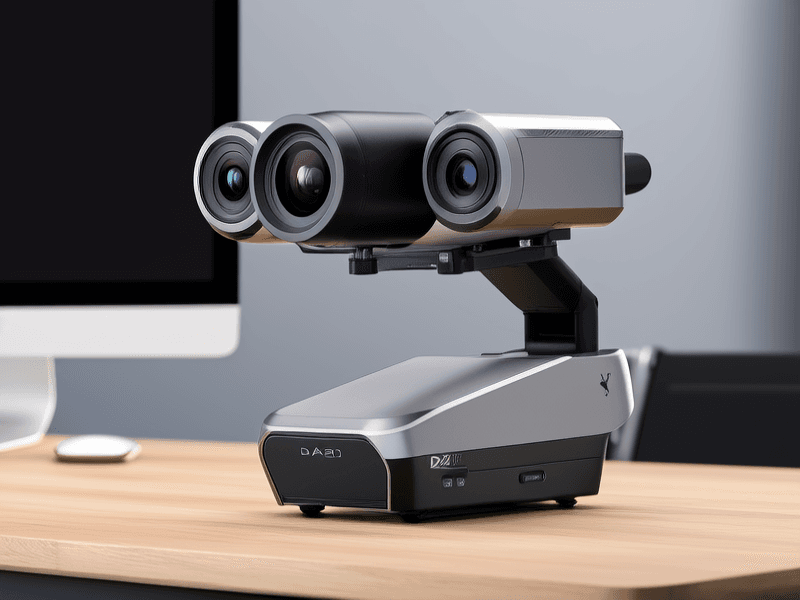
Revolutionizing professional aerial surveillance and imaging, the DA20 Multifunctional Gimbal sets new standards for search and rescue drone operations and law enforcement applications. This advanced 3-axis gimbal system combines industrial-grade stabilization with 22x optical zoom and intelligent night vision capabilities, making it the ultimate solution for professional aerial photography and monitoring missions. Unparalleled Imaging for Professional Drone Applications The DA20 Gimbal System represents the pinnacle of aerial imaging technology for search and rescue drone operations and law enforcement surveillance. Featuring a powerful 1080p high-definition camera with 22x optical zoom, this professional 3-axis gimbal delivers crystal-clear footage even at maximum magnification, essential for critical identification tasks. Key imaging features for aerial surveillance include: 22x optical zoom with 58.3°~3.2° horizontal perspective range 1080p HD distortion-free video at 30fps Industrial-grade three-axis stabilization for law enforcement drone operations F1.6~F3.5 aperture range for optimal light control 4.7~94mm focal length for versatile shooting scenarios Advanced Technical Specifications for Professional Drone Gimbal Systems Video Output 1080P RTSP H.264/H.265 Working Voltage 18V-72V wide input range Power Consumption 160mA (1A with spotlight) Stabilization System Professional 3-Axis Gimbal with Industrial-Grade Motors Spotlight Technology 3000nits, 6500K Color Temperature for True Color Reproduction Thermal Management Advanced Thermal Management System for Extended Operations Operating Temperature -10°C to +50°C (Ideal for Various Environmental Conditions) Control Interface SBUS/UART/Ethernet Advanced Night Vision for Law Enforcement and Search Drone Operations The DA20's integrated variable focus spotlight revolutionizes night operations with its 3000nits brightness and precise 6500K color temperature, ensuring accurate color representation critical for identification purposes. The sophisticated thermal management system maintains optimal performance during extended surveillance missions. Advanced night vision capabilities include: Intelligent auto-zoom spotlight synchronized with camera optical zoom High-efficiency LED technology with 6500K color temperature for natural illumination Advanced thermal management for sustained operation in demanding conditions Precision beam control optimized for search and rescue drone applications Professional Drone Gimbal Applications: From Search Operations to Agricultural Monitoring The DA20 Gimbal System excels across multiple professional domains where precision aerial surveillance and imaging are critical: Search and Rescue Drone Operations: The powerful 22x zoom combined with advanced night vision capabilities makes this system indispensable for locating missing persons in challenging environments and low-light conditions. Law Enforcement Drone Surveillance: Monitor situations from safe distances with crystal-clear detail during both daytime operations and nighttime missions, enhanced by the 6500K color temperature spotlight. Agricultural Monitoring Solutions: Conduct precise field surveys and identify crop health issues with the system's exceptional zoom capabilities and stable 3-axis gimbal platform. Professional Aerial Photography: Capture cinematic-quality footage with professional-grade stabilization and optical performance that meets industry standards. Critical Infrastructure Inspection: The reliable thermal management system ensures consistent performance during extended aerial surveillance missions. Intelligent Control for Professional Drone Gimbal Operations The DA20 offers sophisticated control options that enhance operational efficiency for search and rescue drone missions and law enforcement applications: One-click return to center position for rapid target acquisition One-click downward orientation for quick inspection tasks Multiple control interfaces (SBUS, UART, Ethernet) for system integration Network port for advanced law enforcement drone system integration Compatible with various search and rescue drone platforms Why the DA20 3-Axis Gimbal Excels in Professional Drone Applications The DA20 Multifunctional Gimbal represents the pinnacle of drone gimbal technology for professional applications. Whether deployed for critical search and rescue drone missions, law enforcement surveillance operations, or precision agricultural monitoring, this system delivers unmatched performance through its advanced 3-axis stabilization and intelligent thermal management. The integration of 6500K color temperature lighting with sophisticated thermal management ensures reliable operation across all environmental conditions, making the DA20 the preferred choice for professionals in aerial surveillance and imaging. Ready to enhance your search and rescue drone capabilities or law enforcement operations? Discover the DA20 Multifunctional Gimbal today and experience professional-grade aerial surveillance technology!